
Chile is located in South America. Peru is located to the north and Bolivia is located to the north east. Argentina is located to the east. The west and south side is covered by Pacific Ocean. The geographical area of Chile is 756122 Sq. Km. The capital of Chile is Santiago. It is also the largest city. Other important cities are Valparaiso and Concepcion. The official language of Chile is Spanish. The currency is Chilean Peso. The religion of local people is Christianity. Out of the total population 70% are Roman Catholics, and 15% are Evangelists. The remaining population constitutes atheists, Jews and local belief. The literacy rate of Chile is more than 96%. The life expectancy is 76 years. Football is the major sports of the country. Tennis is also very popular in Chile. The literature is rich, and Chile has produced Nobel laurates in literature. Chile is exporter of copper, mineral products, fruits, wine, paper, pulp, meat products and fish products.
Chile is a ribbon shaped country with coast line of 4300 Km long along the Pacific coast. The average width of the land mass is around 177 Km. The land of Chile can be divided in to three geographical regions. The regions are Andes Mountain, Chilean coastal ranges and Central valley. Andes mountains run north to south. The territory in the north starts with Atacama desert and ends in south with Cape Horn. The Atacama desert is the driest part of Chile. It is also the driest part of the world. The Andes mountain ranges covers the eastern part along the Argentina border. Low rages of mountains are found along the eastern coastal region. Andes have many snow covered peaks. The Central valley have rivers, lakes, waterfalls and rapids. The area is fertile and have agriculture, horticulture and inland fishery. Some of the large animal farms are found in this region. The southern part consists of peninsula land and clusters of islands.
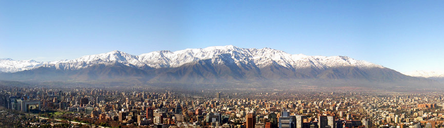
Chile is also divided in to some zones from north to south. The northern part is called the Norte Grande or far north. The dry Atacama desert region comes under this zone. It is along the border of Peru and Bolivia. The Atacama desert is rich in copper and nitrate deposits. The second zone is Norte Chico. It is also called near north. It is located south of Norte Grande. Some rivers flow in this zone and form river valleys. The height decreases towards the coastal region. Fertile land and good irrigation facilities makes this zone suitable for agriculture and animal husbandry. The next zone is the Central Zone or Zona Central. This zone is most populated and have the cities and industrial areas of Chile. The Central Zone is also very fertile with large rivers and lakes. Large agriculture, fruit, vegetable and animal farms are found in this zone. The cities like Santiago, Valparaiso and Concepcion are established in this zone. The South zone is the next zone. This zone is the lake district of Chile. Lakes are formed by rivers flowing from Andes. This area is full of forests and natural vegetation. This zone is active in timber and wood extraction. Raw materials for pulp and paper are found from this zone.
The southern part is called Austral zone. It is full of fjords. Due to glacial erosion fjords are formed. This area is sparsely populated. The northern part has temperate desert climate. The central part has mediterranean climate suitable for fruit and flowers. The southern part is damp and cool. The coastal region has pleasant climate. It is suitable for fish production. Chile is a major producer of sea fish and some marine products. The northern part is rich in mineral resources. The central part is famous formats agriculture, animal farms and fruit farms. The coastal region is active in marine fishery. The southern fjords have oil, gas and coal deposits. Chile is rich in mineral resources. It is the leading producer of copper metal and concentrate. It is rich in minerals of copper, gold, silver, iron ore, manganese, chromite, molybdenum and other minerals. Chile also have deposits of lithium, rhenium, selenium, iodine, potash, nitrate, arsenic, boron, lime stone and salt. Chile produces 34% of copper of the world production. Mining contributes 16% of the GDP of Chile, Copper ore and concentrates constitutes 85 % of the total mineral and metal exports of the country. Chile exports metal and minerals to countries like China, USA, Japan and South Korea. It imports natural gas from Qatar, Argentina and Equatorial Guinea.
Chile imports petroleum products from Gulf countries. Coal is produced from Magallanes Coal basin of south Argentina. Chile has state mining companies to extract, process and export mineral and metal products. The important companies are Shell-CAPSA, CODELCO, SQM and MOLYMET. Hydro-projects contribute major power for the development of Chile. Around 45% of power is generated by hydro projects. Coal based power plants contributes 30% of power for the country. The remaining power is generated by based power plants. Mining and metal extraction sector consumes around 40% of power produced in the country. Byproducts like gold, silver, selenium, arsenic, molybdenum and rhenium are produced from the smelters of copper. Mining and metal industries provide maximum employment to the workers. Mining companies like BHP Billiton, Rio Tinto, Freeport-McMoRan, Barrick Gold Corporation, Xstrata and Cominco Resources work in Chile. Geo Packs produces crude oil and natural gas in Chile.
The geological formation started in the Paleozoic era. Rocks like mica schist, phylllites, gneiss and quartzite are formed during this period. Most of the important minerals are formed during Precambrian period. Precambrian rocks are found in the Andes mountains and in the Atacama desert. Paleozoic rocks are found in coastal areas of some districts. Up to Mesozoic era, Chile was part of the super continent Pangea. It was closer to Africa, Australia, Antarctica and India. The formation of Andes Mountains started at the early part of Jurassic period. Andes became stable during the Cretaceous period. Altiplano plateau was formed during the tertiary period. Quaternary glaciation left visible marks on most part of the country. The glacial marks are still found in southern part of Chile. At present glaciers cover 27% of the land area of Chile. Around 80% of glaciers of south America are found in Chile. The large glaciers are the North and South Patagonia Ice fields. The northern part has two important glaciers as Tapado and Tronquitos. The central part has five important glaciers, which are named as Universilad, Cipreses, San Fransisco, Esimeralda, and Juncal Norte glaciers respectively. The southern part has 50 important glaciers. Ice fields are found in Aisen and Magallanes regions.
The continental margin of Chile is very active. Chile has number of volcanoes. Frequent earthquake and tremors are common in many parts of Chile. Chile lies along the Ring of Fire of Pacific Ocean. There is regular earthquake, and tsunami along the coastal region of Chile. Chile. has 36 active volcanoes. More than 2000 volcanoes are dotted along the Andes mountains. More than 44 volcanic eruptions occurred since recorded in 1820. In the last 20 years, there was 15 volcanic eruptions. Earthquakes are common along the coastal region of Chile. Tsunami follows the earthquakes. Landslides occur in Andes mountain after volcanic eruptions and earthquakes. Ojos del Salado is the largest volcano in Chile. It is located along the border with Argentina. It has height of 6893 meters. There is a crater with a lake at the height of 6390 meters. Easter island is a volcanic island. It consists of three extinct volcanoes. There are many extinct volcanoes near this island. These volcanic islands are located inside the Pacific Ocean. The Juan Fernández Islands are also formed by volcanoes. Andes mountains are formed due to convergent of plate boundaries. During the Precambrian and Paleozoic period, the boundaries of the plates took shape. Slowly the plates are formed, and plate boundaries are developed in to subduction zones. A subduction zone was formed along the boundary of South American plate and Nazca plate. The Nazca plate subducted the South American plate. So, the continental margin of Chile is very active with volcanoes, earthquakes and tsunamis.