Papua New Guinea---History, Geography and Geology
Tropical rain forests cover the main land and islands of Papua New Guinea. Pine forests and alpine forests are found on higher altitude areas. The swamp forests are found along swamps and water bodies. Mangrove forests are found in the delta region of rivers. Papua New Guinea is agricultural country. The main crops are rice, potato, sweet potato, oil seeds, vegetables, tropical fruits and coconut. The commercial crops are coffee, tea, cocoa, rubber and oil palm. Coffee, copra and cocoa are exported to other countries. The flora and fauna are closer to the flora and fauna of Indonesia and northern Australia. Mining is a major economic activity here. Minerals of copper, gold, silver, platinum, cobalt, nickel and tin are found in Papua New Guinea. Oil and Natural Gas are also found here. Tourism is other important area of the economy. Tourism provides employment and generates revenue for the local people. Nature visit, trekking, surfing and holidaying are attractions for the visitors.
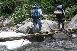
The major tourist attractions are Spike River, Kokoda Track, Mount Wilhelm, Owen Stanley Ranges, Umali volcano, Tavurvur volcano, Milne bay, Rabaul caldera, Mount Gilwe, Lake Galena, Black cat Track, Puravi River, Bull dog Track and Bismark Range. The Kokoda Track starts from Port Moresby in the south to Owen corner and the Kokoda village in the north. The track passes through rain forests and wildlife parks. The track is closer to some beautiful natural features. The Kokoda Track is very popular among the visitors and nature lovers. The Lae rain forests region is rich in flora and fauna. It is best for wildlife and nature visit. It is located in the Morebe province. The Moitaba Wildlife sanctuary and zoo near Port Moresby is very popular among the local and foreign tourists. The Botanical Garden near Papua New Guinea University is home to species of plants found in this region. The Kokopo War and Culture Museum of New Britain Island is a place of attraction for tourists. The Mount Balbi volcano of Bougainville is also popular among the visitors.
The main land and islands constitute the country of Papua New Guinea. The physiological features are Northern Ranges, Sepik-Ramu Plains, New Guinea Highlands, Owen Stanley Range, Papua Foot Hills, and Fly-Strike Land Low lands. The Owen Stanley Mountain Range runs from east to west. It rises sharply from the coastal plains.. Mount Wilhelm is the highest peak with a height of 4500 meters above mean sea level. The Sepik and Fly rivers are very important for Papua New Guinea. The coastal plains are fertile and beaches are sandy. The climate is tropical, hot and humid here. The rainfall is heavy in summer months. The dry period is from December to May. The rainy season is between June to November. Snow fall is common during the months of December and January in the high altitude regions of Central Mountain Ranges. The hills and mountain ranges are highly degraded and eroded by a number of streams and rivers. Coastal plains, Deltas and low lands are found in the lower altitude areas.
The New Guinea Island and the adjoining smaller islands are formed by the collision of the Australian Plate and Pacific Plate. The sediments and volcanic materials combined to form these islands. The geological features formed due to tectonic activities are named as Platform, Northern Mobile Belt, Oceanic Crust and Island Arcs, Papua Ophiolite Belt of south, and Bismarck Volcanic Belt of north. The central Platform is stable and composed of crystalline rocks. The Platform is covered by Mesozoic to Tertiary sediments. The Mobile Belt is around 150 km long. It is deformed many times since Mesozoic period. The Oceanic crust is formed by sedimentary and volcanic material depositions since early part of Tertiary period. The Island Arc volcanism started from middle and late Tertiary period. By late Pliocene period the land mass of Papua New Guinea.took the final shape and got all its physical and geological features by late Pliocene period. Wide spread volcanic activities affected the region till now. Earth quake is commonly felt in this region every year on a regular basis. A number of volcanoes are active in this region. The Tavurvur volcano and the Rabaul Caldera are active but not violent. But Ulawun volcano is active and dangerous in nature. It has volcanic activity on regular basis. It has irrupted 22 times in the recent years.Consistent explosion with deposition of ash and lava in the surrounding region continued in the present days. Threat of structural collapse may lead to large scale explosion in the region. Due to volcanism and lava depositions, the region is rich in minerals of gold, copper, silver, platinum, nickel, cobalt, tin and titanium. Deposits of oil and natural gas are also found in the coastal region of Papua New Guinea. Gold deposits are found as lodes and placer deposits in many parts of the country. The silver is available as byproducts of gold. The country emerged as major producer of copper and gold. Industrial minerals like limestone, asbestos, gypsum and beryl are reported from Papua New Guinea.